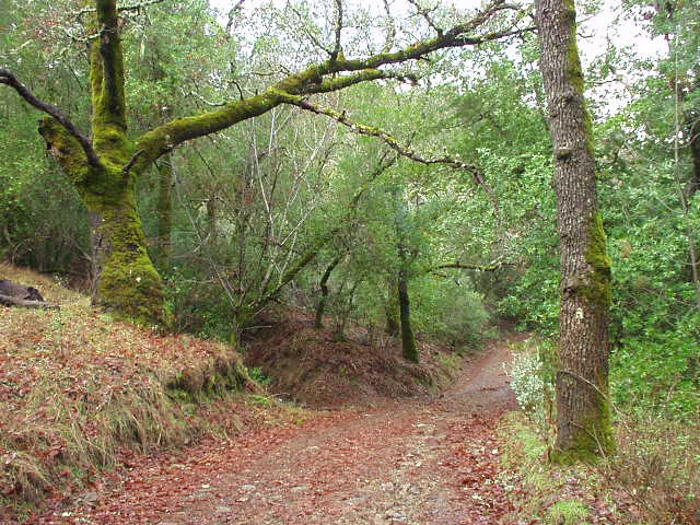
Henry Coe State Park, CA

“So how far are we going to be hiking each day?” asked Sarah, friend and bad-weather backpacking partner, on the phone the day before we departed on one final adventure for 2002. “Well,” I replied, trying to mask the fact that during the busy week, I had really put no thought into planning the trip, “I had in mind something like Murietta Falls. So maybe up to 15 miles a day?” I heard a little bit of silence on the other end of the phone. “But,” I continued, “if we just did 6 miles a day, I’d be happy.” Sarah seemed to be more agreeable to the latter, and even had picked up a map for Henry Coe State Park earlier in the week. So it was just a matter of her coming over on Saturday morning, and us driving over to Henry Coe.
Never did I ever think, however, that even *6 miles a day* would
turn out to be ambitious…
The Drive Up
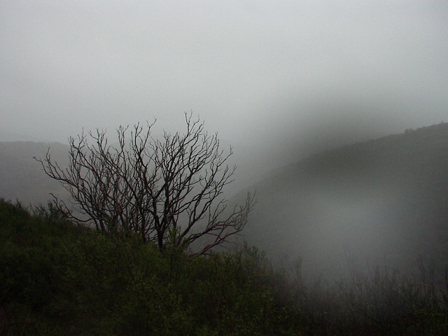
Indeed, though Tori had warned me earlier in the week that rain was forecast for “one of the days you are camping”, the sun was shining and the roads were drying after the rains of Friday night. First time in several days I could put Lina the Z3‘s top down! So top-down driving we went, through the wonderful sweeping backroads south of Morgan Hill to Henry Coe. Perfect for sports car driving, as Lina took the turns with aplomb with her inline-6 revving silky-smoothly through the powerband. This was simply a classic motoring day, with virtually no traffic, verdant hills and crisp clean air. Over one of the best backroads the East Bay has to offer.

After 12 miles of this, we arrived at Henry Coe. There weren’t too many cars in the parking lot. Perhaps people had heard about the rain, or were more inclined to stay warm inside and watch the final football games of the regular NFL season.
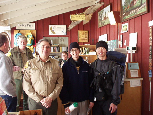
I went to the bathroom while Sarah went inside the Visitor’s Center to register, etc., and when I found her a friendly volunteer guy was showing her a clay-model topographical map and giving advice on where to stay. Since I came late I didn’t catch all of it, but I did here him say “avoid China Hole” and something about being trapped by various creeks if the rain got really bad overnight. He also mentioned several outhouses we could stay in to stay dry if we needed to, though he also mentioned something about some viruses related to the Ebola virus except that “this virus only kills 50% of people, whereas the Ebola virus kills 90%.” Great, 50% is still too high though, I thought! Apparently, so did Sarah, because she quickly remarked that she’d prefer to camp in tent in the wilderness instead!
The friendly volunteer dude also mentioned how if we had to, we were entitled to camp anywhere, because “out there it’s a matter of survival. There was one time I went camping, and I had to start a campfire to keep us warm, which is against the rules but hey–if that’s the only way to prevent hypothermia, what can you do?” I appreciated that philosophy, as opposed to that of several other parks in California which have stringent rules about where you can camp plus a hundred rules of what you can’t do, etc.
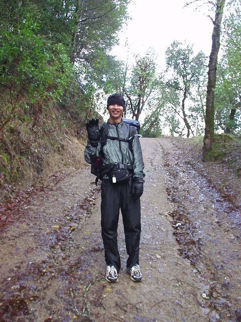
We finally decided on a route that was something of a hybrid between a loop and an out-and-back course. By this time it was already 1:15 p.m. or so, so there was only going to be about 4 hours of daylight remaining. To make things more interesting, just as we decided on our route the sky suddenly turned gray and it started raining! What timing–we had made it to Coe with the top down without feeling a single drop of rain, and now just as we were going to start hiking, it was coming down pretty hard!
The Hike
I had brought my umbrella just in case for this occasion. The umbrella was something recommended by Ray Jardine of Pacific Crest fame, plus something I had very successfully used during the Murietta Falls trip in January, despite only wearing a short-sleeve jersey that day in temperatures below 40 degrees. Today, I’d be wearing my cycling windbreaker in addition to the aforementioned jersey. I also was wearing a headband as opposed to the full fleece “quickdraw” hat I wore at Murietta Falls, which I suspected would be overkill this weekend, which I expected to be warmer than at during that trip.
“I’m so happy it is raining! This is so nice!” I exclaimed to Sarah. Indeed, there was always something appealing to me about hiking in the rain. The sound of rain drops is soothing; the air is cleaner; and there’s always the sense of adventure and rugged individualism afforded by such conditions. The trick is to stay warm.
We hiked for a couple of hours into slightly higher territory. As the day went on, the rain started coming down harder, and the wind picking up. At some points the rain was going completely horizontally, and I had my umbrella pointed sideways to shield me from both the rain and the wind. Eventually I was beginning to regret only bringing the fleece headband instead of my full hat, as I seemed colder than at Murietta Falls despite wearing a windbreaker. This certainly lent credence that 80% or whatever heat escapes from one’s head, plus the advice that “if your extremities are cold, put on a hat!”
Sarah and I somehow got off the course we were intending to go on, and was heading right towards China Hole, which is where the volunteer guy strongly recommended we did not go! No problem, after a quick consultation of the map, we knew where to go and how to get there. Soon after was the most comical moment of the day. Well, as we hiked towards the Cougar Trail, there was a big hulking dark animal right ahead, in our path! “What is that?!” inquired Sarah. We decided that it was a wild pig. “Are wild pigs dangerous?” asked Sarah. “Can humans outrun them?” I had never encountered a wild pig–though I did read a couple of months ago that they were being a big menace to the San Jose community, coming into people’s backyards and digging up the place–but to the latter, of whether we could outrun them or not, I was pretty sure the answer was “NO!”
So this is what we did: we actually turned around, and headed back the other way, not completely decided on what we should do.
A couple of minutes later, I couldn’t help but burst out laughing. “I can’t believe we just changed our plan because there was a WILD PIG in our way!” Soon Sarah was laughing too. I mean, it’s not like a PIG could tear off a human’s head like a bear or lion could do, right? So we turned around yet again, going in our original destination, but semi-hoping that the pig was now gone. I only say “semi-hoping” though because I was hoping that, if a pig was going to stop us, I’d at least could take a picture of it to prove to people who asked!
So there I had my camera out while offering assurances to Sarah that, if the wild pig had not in fact left, I’d protect her (which she thought was pretty funny as well!) And all of sudden–oink oink (okay so the pig did not actually make that noise)–there’s the wild pig! Wow, it was fast! It ran away so quickly that I, unfortunately, could not take the picture that I wanted of it.
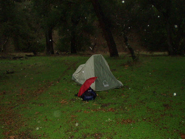
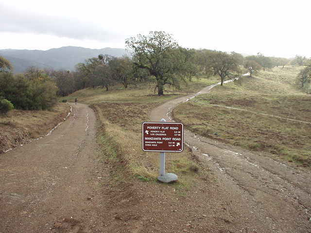
About a mile later was the saddle between the hills, disected by a shallow creek, where Poverty Flat lay. We looked for a place to camp and, decided, we’d have to cross the creek after all for a campsite. At this point it was just a simple boulder hop to get across. And by this time, with the rain still pouring down on us, both Sarah and I were wet/cold enough that we decided this was as far we would go tonight. We efficiently set up her new tent (which is the same model as my tent, which helped in knowing how to put it up as quickly as possible), and in we went.
Unfortunately, most of our spare clothes and even our sleeping bags were wet at this point. I had the foresight–a result of having to sleep in a wet sleeping bag at Murietta Falls, to pack my sleeping bag in some plastic bags, but it was still wet. Two regular-sized Target department store bags do not cut it! Next time I will use a full-size garbage bag or something. And my spare clothes–which included some nylon socks and polyester shirt–were soaked. Well, at least the fleece socks I packed were dry along with my long johns, so I changed into those, but I slept in my short-sleeve jersey which was drier than the soaked polyester shirt.
Sarah’s gear did not fare any better–in fact, I think her stuff was even wetter than mine. But she is not one apt to complain. So we got into our sleeping bags, shared some food (including peanut butter and jelly sandwiches, pretzels, bananas, Trader Joe’s Cat Cookies [for people], and Tandoori Naan). After 5:00 p.m. it was already dark and though it was really early, there was not much else we could do except sleep. So sleep we did.
The Night
I woke up in the middle of the night, not having any clue as to what time it was, just listening to the rain. It was still really coming down outside!
Raindrops were playfully tapping on our tent, coming on with an occasional ferociousness and harshness, but then rescinding back into a melodious, soothing rhythm. Between downpours I could barely make out the frogs nearby who, for whatever reason, decided to make their home by the creek. Ribbit, ribbit. Then, kaboom! There was now thunder and lightning. Or, should I say, lightning and then thunder. As I made a habit of doing ever since Mt. Shasta, I counted the number of seconds between the flashes of light and the deafening roars of the sky. 25 seconds or so, or meaning that the lightning was approximately 25,000 feet above us. We were safe.
My sleeping bag was even feeling fairly dry at this point. It’s a mummy bag, and I had fully zipped it up and drawn the cord for the face opening fairly tight, with just my mouth, nose, and eyes peaking out of this hole. Felt like a mummy all right. I was fairly warm, at least.
Still, despite the sanctity of our dwelling here in the wilderness and the soothing tapping of the rain, it was hard to get back to sleep again. How does one sleep after taking a long nap after 5:00 p.m., one who over this holiday break has been accustomed to going to bed at 2:00 a.m. or so? I think it took about 4 hours for me to fall back asleep. The next thing I knew, the sun was up and, Sarah, ever the early riser, got up and out of the tent, and (I think) went hiking for a little bit. The rain, evidently, had tapered off, if not entirely ceased. So I was up myself, at 8:30 or so.
The Hike Back
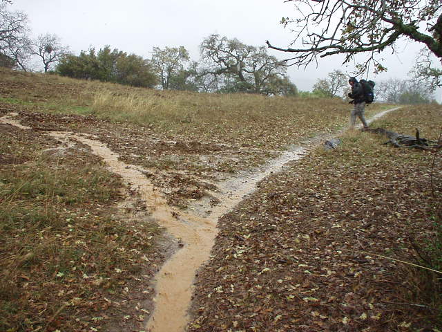
By the time we had packed the tent back up (quickly)… it was raining, yet again! So here we made the decision to simply hike back to to Coe Headquarters (where my car was), even though this was just 3.5 miles back. So much for my 6 miles a day! But it was not to be without another adventure.
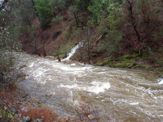
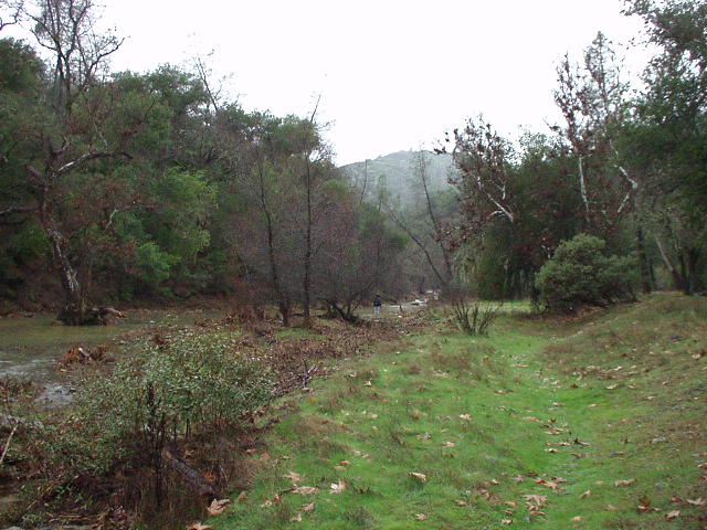
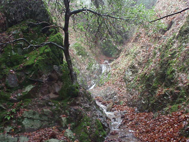
You see, this is because–as Sarah had realized even before I had woken up–that the creek had swelled dramatically. The creek–which was more like a stream that we easily had boulder-hopped the night before–was more like a fast-flowing river, rushing with cold, muddy water, easily waist deep, if not higher. And we were going to have to cross. But how?
We walked up and down along the creek, trying to find a place that was relatively shallow, and relatively slow-moving. “Relatively” is the key word here. There was no place the creek was shallow or stagnant. But both qualities were more or less better in some areas than others. Finally, after about 20 minutes or so of prevaricating, we decided on one section, and decided to go for it.
We started halfway in, with me in the lead. Suddenly it occurred to me that the creek was going to be high enough to reach my waist pack, which contained my non-waterproof camera. To Sarah’s dismay, I’m sure, I then backed out of the water. It was cold, and I’m sure she would like to just get over with it, especially after we had already immersed 2/3rds of our bodies in the water.
But I really wanted to salvage my camera. So I packed it in a ziplock bag, and repositioned it in the upper compartment of my pack… and then hoped I would not fall into the rushing current.
We found some long, strong sticks to help us keep our balace while wading across while also allowing us to gauge just deep the water was before taking steps forward within the water. This time Sarah went first. “The current is strong!” she exclaimed. But a few seconds later–which actually felt like a fairly long bit of time–she had made it across. Now it was my turn.
The creek was strong all right. Suddenly I remembered something I had read in, of all places, a financial book I was reading last week about surfers in Hawaii: a piece of advice on not to fight the current, but rather, go with the flow. This seemed to help. Soon I was out myself.
We gave each other hi-fives. Fording the creek with waist deep water was
interesting.
“Well, you had wanted to go swimming,” I joked to Sarah, alluding to the swimsuit she had packed for the trip but then left in the car after realizing that this December weekend was probably not the best time to go swimming. “My clothes had finally dried out being wet all night and the first thing we had to do was cross a creek!” she exclaimed.
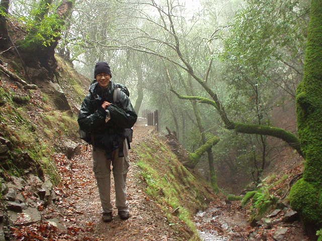
The rest of the hike was much less eventful. There was some significant elevation gain, as opposed to the first day, but nothing on the extreme end of the “challenging” scale. We saw some more wildlife–including a flock of birds I had completely mistakenly called “ducks” at first. Those were wild turkeys! I had tried to photograph them, but they were bashful and mooseyed on away from us, too far from the reach of my digicam.
We continued on for another hour or so when we–finally–saw someone else on the trail. It was an elderly woman, hiking solo. “There’s a fire burning and some hot chocolate inside the Visitor’s Center,” she cheerfully told us. Cool–it was just half-a-mile away.
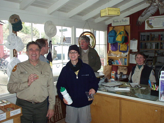
Which took almost no time to get to. We entered inside, and sure enough, a warm fire was a-glowing. And the friendly volunteer guy, along with his wife and the ranger, were there. The volunteer guy even had made cookies for everyone, which he eagerly insisted we eat. “They’re my mother’s recipe, and they’re not low-fat!” he told me.
We chatted for a bit, mentioning the fording of the creek–before heading back on our way. As we left the Visitor’s Center the volunteer guy told us, “You’re our ‘deep water campers’ this weekend!” Hehe… in Sunol Regional Park, we were remembered as “the camping people” [who camped in some crazy conditions] by the rangers up at Murietta Falls, even some weeks afterwards, and here, the ‘deep water campers’. An appropriate name considering that–as Sarah and I figured out–we had done more bad-weather backpacking trips that good-weather ones.
I did promise Sarah that, in 2003, maybe we would actually do some good-weather ones. We’ll see!
Trip Summary
- Hikers: Felix Wong & Sarah Toas
- Distance: 9 miles
- Highest Elevation: ~2400 feet
- Duration: 2 days
- Difficulty: easy-moderate

One comment:
Beautiful scenery and great picture. Thanks for your sharing.