A Backpacking Trip in the Black Hills of SD (Black Elk Wilderness)

My friend Diana wanted to go on a three-day backpacking trip with her fellow researcher Saar from Belgium. Knowing that I am often game for such sort of adventures, she asked if I would be interested in coming and to help plan it. “Of course,” I said.
After tossing around a few ideas we settled on the Black Hills of South Dakota, which are a 5.5-hour drive from our hometown of Fort Collins, Colorado. I could not find any write-ups online about any three-day trips other backpackers had done on this area, so I came up with the following. By posting this article, I hope to provide useful information for other hikers wishing to do such a trip.
Our journey took us by Harney Peak—at 7,242 feet, the highest summit between the Rocky Mountains and the Pyrenees of Europe—and Little Devils Tower, Sylvan Lake, Cathedral Spires and Mt. Rushmore. It also included the five best hikes in all of South Dakota according to Trails.com.
At approximately 34 miles in length with a moderate amount of climbing, it’s doable by reasonably fit people without requiring crazy amounts of effort or distance each day when done over a three-day period (which included driving). Yet, it was long enough that we each felt a great sense of accomplishment by the time we had arrived back at the car on the third day.
Planned Route
The initial route I mapped out is shown by the navy blue line below tracing a counter-clockwise loop through the Black Elk Wilderness National Forest beginning and ending at the Willow Creek Trailhead off Highway 244. This trailhead is right across from the Mount Rushmore KOA and is about seven miles west of Mt. Rushmore.
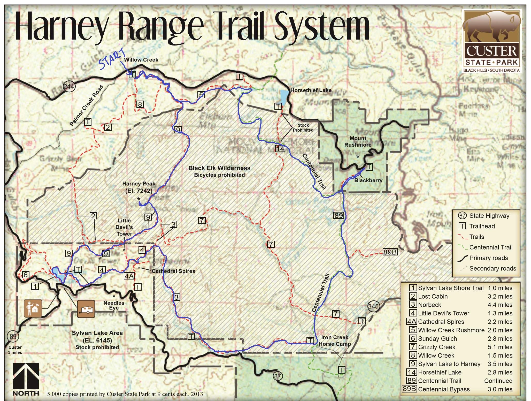
The plan could be summarized as:
- Day 1: Hike 10 miles past Harney Peak and Little Devil Tower to Sylvan Lake. Camp.
- Day 2: Hike 14 miles past Cathedral Spires towards Mt. Rushmore. Ambitiously, hike an additional 3 miles round trip to/from Mt. Rushmore if time permitted. Camp.
- Day 3: Hike 10 miles back to the car and drive back to Fort Collins.
We ended up not hiking the extra segment to Mt. Rushmore due to a late start on Day 2, running out of daylight, and tired feet. Additionally, we inadvertently added on a half-mile here and there while getting lost looking for trails. Signage on much of the trail was often lacking or confusing.
Day 1
We left Fort Collins at 7:30 a.m., and after having a buffalo burger lunch stop in Custer, SD, we arrived at the Willow Creek trailhead by 2:00 p.m. Hiker registration slips (free; one per party required) were available at the trailhead in order to let the Park Service know of your plans. For good measure, I left a note that I had printed at home on the dashboard informing the ranger of my route and plans along with the words “there is nothing valuable left inside this vehicle” so as to reduce the chances of the car getting towed or broken into.
We then walked a half-mile looking for Trail 9, which per the map above I mistakenly thought was the first trail of the route. Tip: start on Trail 8 at the trailhead by the parking lot. This takes you to Trail 9 after 1.5 miles.
From there, we made no more wrong turns on Day 1, although we did frequently wonder which of the tall formations in the distance was Harney Peak. Its distance from the Willow Creek trailhead is just over five miles, but my Microsoft Band 2—which last week received an “Explore” tile to track hiking—was overestimating distance traveled by about 30%. (It seems that in order to achieve over eight hours of battery life using Explore mode, the Band 2 polls GPS only occasionally to record waypoints and relies on another sensor like maybe the accelerometer to estimate pace and distance.) This added to my confusion as of which one was Harney.
It turned out that Harney Peak is the one with a distinctive lookout tower on top. It is the only mountain in this area with a tower; this small building was built in 1939 as a place to spot where there were wildfires. It also turned out that the 360-degree, panoramic views from this tower were astounding.
From there, most of the hard climbing was done for the day and it was a pleasant descent towards Little Devils Tower. We got to Sylvan Lake at 8:10 p.m. (20 minutes before it got dark) and set up our tents in a nice quiet area off the trail near the lake. I then realized that my water filter/pump had a broken handle, but I got the pump working in a less-than-satisfactory manner after using a bit of duct tape to plug the hole on the shaft where the handle used to be. It took a while to pump water—and it turned out not even to be necessary because there was running water near a parking lot on the east end of the lake. But at least the filtration device was now functional enough for the next couple days.
Mosquitoes were looking for a feast so we crawled into our respective tents by 9:15 p.m. I managed to fall asleep right away despite being a little cold—cool enough that I had completely mummified myself with my Mountain Hardware Phantom 32 sleeping bag except for a three-inch hole to breathe out of. I did wake up a few times at night only to fall right back asleep after listening to the soothing sounds of raindrops tapping against the top of the tent.
Unfortunately, the ladies reported neither of them got any sleep until it started raining at 2:30 a.m. Additionally, their shoes got damp despite being placed underneath the rainfly. They also said they were a little cold despite having warmer sleeping bags and two bodies in their tent. All this, I think, contributed to having a 10:20 a.m. hiking start on Day 2.
Day 2
We started the second day by circumnavigating the one-mile trail around Sylvan Lake. This little side excursion was worth it due to the beautiful views of the water and rock formations—one of which had rock climbers on it.
We did, however, have some trouble finding Trail 4, and wandered back-and-forth about a half-mile in order to find it. Tip: Trail 4 is east of the east end of Sylvan Lake, about two parking lots over. There’s a water spigot here too, although I suspect it is only turned on during the non-winter months.
Trail 4 surprised us with having quite a bit of uphill. In fact, at one point we were nearly as high as Harney Peak.
At one point, I stopped to take a food break and to let the ladies get a little head start on me. “I’ll catch up,” I said. Unfortunately, I did this at an inopportune moment because a short distance later was a crucial turnoff: one that turned left to remain on Trail 4, and another to the Cathedral Spires.
Neither of my friends had a map so I could not be confident they knew which was the correct trail to turn off on. Furthermore, I could see neither of them down the trails and my shouts of “Diana!” were met with no response. So I picked the left trail and started running. I stopped to ask some other hikers if they had seen Diana and Saar. In the midst of my confusion happened something a little bizarre.
“Hi Felix,” said a woman I did not recognize (but I had not looked at more than a half-second). “Did you lose your friends?” I wanted to ask “how did you know my name?” but figured that she must have encountered the ladies down the trail and they told her my name. But then she (and the other hikers) said they didn’t see my two companions. So I turned around to run down the other trail and sure enough, ten minutes later, I found them waiting and eating by the Cathedral Spires.
(Now that I am typing this, I am guessing that the woman who knew my name must have encountered us at the top of Harney Peak and overheard my name. Mystery solved, I think!)
Unfortunately, the trail Diana and Saar went down was the wrong one. So we had to go back up, adding on yet another third-of-a-mile.
By this time it was also steadily raining. There were also numerous downed trees that slowed us down. Finally, a few miles after turning north onto the Centennial Trail, we (I) got a little directionally discombobulated again when we encountered a T-intersection at what turned out to be Trail 7. We made a right instead of a left turn onto it, and ended up having to backtrack after realizing our mistake in order to continue on the Centennial Trail. This was one of the places where I felt better signage was needed.
Those were some of the reasons we ended up not going all the way to Mt. Rushmore as initially pondered that day. Instead, by 8:00 p.m. we crossed a creek where I pumped some water, and set up our tents in a nice little plot of land just beyond. We all ate ramen noodles and some snack foods before retiring for the night.
Day 3
The night was a little warmer than the night before, but all of us slept a little worse. It took me an hour to fall asleep, and the ladies reported neither of them got any shuteye until dawn. So we had another late start (10:00 a.m.) The good thing was the distance to hike on this day was shorter than the previous.
The bad thing was I had underestimated the distance as 7-8 miles. It turned out to be closer to 10. Also, due to some pretty gnarly creek crossings and frequent rain, Diana was soaked and her feet were hurting a lot. Saar’s were too along with an ankle. To compound the difficulty, there were more downed trees on this day than any of the preceding ones along with a surprising amount of climbing.
Still, the two ladies were real troopers. With the feet issues, they were unable to hike very fast, but they kept chugging along at a steady 40-minute-per-mile pace or so.
When we got back to the car we had a real sense of elation. Part of that was because we could now stop and change into real clothes, but another was due to a feeling of achievement for successfully hiking 34 miles in beautiful, rugged backcountry with 30+ pounds on our backs.
Afterwards, we drove over to Mount Rushmore Memorial National Monument, which I still had a good-for-one-year parking pass from last year’s trip here with Maureen. Saar had never been here and Diana was last here twenty years ago as a kid, so it was well worth the stop. We also got some Double Avalanche cups of ice cream, which sounded better than they actually tasted even for our high calorie-burning bodies. None of us could finish them, but what we could was enough to keep us fueled up for the 5.5-hour drive back to Fort Collins.
Recommendations and Wrap-up
Despite the challenges, this was one of the best backpacking routes I have ever done due to the views, scenery, ample water supplies (creeks and lake), and even toilet facilities. There was also lots of (un-scary) wildlife like chipmunks, elk, geese, frogs, and mountain goats. We also encountered some horseback riders and dogs.
On the other hand, the trails were moderately difficult with numerous downed trees and plenty of elevation gain. It turned out to be a slightly harder hike than I had envisioned, but still well within the abilities of reasonably fit people.
For backpackers wishing to do the same trip in three days but also be able to go to Mt. Rushmore towards the end of the second day, try to start Day 2 no later than 7:00 a.m. We started at 10:00 a.m. which did not give us enough time for the 1.4 mile/hour pace we were averaging.
I think a determined ultra-runner could run the 34-mile loop in about 10 hours (maybe 11 hours if also going to Mt. Rushmore). The number of fallen trees is the principal reason I think it would take that long. A person can run this self-supported by carrying water treatment tablets, many energy bars and gels, and maybe a light rain jacket. It would make for a serious training run, for sure.
Hiking Data
Day 1: 10.2 miles per Strava from 2:15 p.m. to 8:15 p.m.
Day 2: 13.4 miles per Strava from 10:20 a.m. to 8:00 p.m.
Day 3: 9.8 miles per Strava from 10:00 a.m. to 4:30 p.m.
All 3 days: 33.5 miles per Strava
All 3 days: 35.4 miles per Endomondo (not sure of the reason for the discrepancy)
GPX file from Endomondo data (right-click link and Save As to download)
Initial pack weight: 31.0 lbs.
Ending pack weight: 28.2 lbs.
Notes for Myself for Next Backpacking Trip
- Bring water treatment tablets.
- Fix or replace water filter, or consider using tablets instead.
- Bring Vaseline or equivalent to help with shoulder chafing from pack’s shoulder straps.
- Repair the chest strap on the camping backpack that Saar was using (it broke last year before I lent it to her).
- Eventually—after using up all the solid fuel pellets for my Esbit stove—consider getting a compact wood-burning stove like the Emberlit stove. Or experiment to see if I can use sticks and pine needles on my existing Esbit stove instead.


There are 27 comments.
Hi there,
I was just curious if you would have a GPX, KML, or SHP file of your route or any of the trails in the Black Elk Wilderness. I'm in the process of planning a trip of my own and cannot find anything that's half way accurate to use on a GPS or use with Google Earth to make any maps to go off of. Any help would be appreciated.
Thanks,
Levi
Hi Levi. I'll email you a exported GPX file of the whole route on Strava in a few minutes.
Really great read. Heading to the Black Hills at the end of the week and looking to add another trail with my kid. Likely, we will be doing a 4 day trip (he handles the hills well! But I would like to give him extra time).
Any chance I could also get the GPX please? It would be awesome!
Hi Mark, thanks for your comment and for stopping by my blog. I will email you the GPX. Good luck!
I?m planning a trip for this summer. Everything I?ve read said to carry water, but you mention ample water. I?m happy to hear that because hiking in with gallons of water didn?t sound pleasant.
Yah, we had no problems with water. I can't remember how much I brought but I imagine that a couple liters would suffice. There's water at Sylvan Lake (including a faucet!) and there were streams in other parts where we were able to filter water.
Have a wonderful trip there this summer. We really enjoyed our trek there!
One more question... did you need to reserve a campsite near Silvan lake? I know there is a popular campground on the lake, which I'm hoping to avoid.
Thank you so much for posting this. I'm planning a trip to Black Elk Wilderness this summer and, like you, haven't found a great deal of information.
The fact that the loop you did is almost *exactly* as the one I had planned out is even more helpful - although I was thinking about starting at Cathedral Spires, hiking over to Sylvan Lake, up to Black Elk Peak, over to Mt. Rushmore and then back down and over to my starting point.
That is great you will be hiking the Black Elk Wilderness this summer. It is such a lovely route. Hope you have a great trip and thanks for dropping a line, Bryan.
Thanks for posting this! Wondering if you got some advice for me. I am planning to hike onlythe 8 mile Black Elk Peak loop as soon as the roads open this spring. We plan to start at Sylvan lake and go counter-clockwise on the loop. I am wondering if you could help me determine how hard it is to find a somewhat flat area to set up tents off the trail. Looks so rocky on the maps. Thinking we would camp a couple miles NW of the Sylvan Lake campground on the Black Elk Peak loop.
Sounds like you have a good trip planned! I don't think it would be hard to find a somewhat flat area to set up tents off the trail. At least we had no issues. There's a lot of empty wilderness out there. Good luck!
My buddy and I just did a variation of your trip, but unfortunately you can not camp at Sylvan Lake without a campsite reservation. We started to set up our tent near the lake and the state park volunteer made us move a 1/2 mile up the road to a designated campsite and we had to pay ~$20 for the night. Apparently when you cross into the state park you need a reservation, but if we had stayed in the black elk wilderness we could have camped anywhere - although it would have been difficult to find a flat place for our tent with all the trees down. Awesome route! We met another group starting your route when we were leaving! Thanks for a great post!
Really appreciate the feedback and info, Charles. Great job on your hike!
Hey Felix!
Great read and awesome trail planning. This seems like a really great trail and would like to hike it at some point(when the temps are reasonable of course). I was wondering if I could get a copy of your route? There doesn?t seem to be a whole lot of designated multi-day backpacking trails that I can find in the Black Hills and this looks perfect.
Thanks!
Hi Felix. Thanks for the detailed description. What time of year did you do this trip? Sorry if I missed that.
Hi David. We went on the weekend of May 26, 2016. I tend to give my articles the date of when I actually did the events, not when I wrote the articles!
Hi Felix, Thanks for a thorough and descriptive trail report! I am planning a little shorter loop than yours this summer: starting at Willow Creek, taking Trail #2 south toward Sylvan Lake (planning to camp somewhere inside the Wilderness boundary as no campsites are available at Sylvan), spend a few hours goofing off around Sylvan, Little Devil's Tower, and Cathedral Spires, then camp somewhere near the junction of Trail #7 & #14 -- hoping to find a place on Grizzly Bear Creek; last day hike back to Willow Creek via Trail #14 to Centennial to Willow Creek/Rushmore #5 to #9N and #8. I'm a little nervous about being able to find adequate places to camp with all the downed trees, and being able to find enough water away from Sylvan. Any recommendations? Thanks!
Hi Sabrina! Thanks for stopping by my blog and for your comment. The hike is such a lovely one, with amazing views, fresh air, not an excessive amount of people traffic, and interesting wildlife. I am psyched for you that you are going to do it this summer!
Regarding places to camp off the trail, I wouldn?t worry about that. Even with the downed trees, the forest isn?t so dense that you wouldn?t be able to find a flat, inconspicuous spot, assuming your tent doesn?t take up much more than, say, 25 square feet of area.
For water sources, it appears from the Harney Range Trail System map that there are streams (shown in very faint blue lines) crossing Trails 2, 7, and 14. You can obtain water from those, using either a filter or water purification tablets.
Otherwise, Sylvan Lake is your best bet. (I filtered water from the lake itself, but that turned out to be unnecessary as there was a spigot in the Sylvan Lake parking lot!) Your hike might be short enough that you can carry enough water to and from Sylvan Lake.
Good luck! Let me know how your hike goes! This is a hike I?d love to do again myself!
Hi! I really enjoyed this read. What month or time of year did you do this trip?
Thanks!
Hi Lisa, thanks for stopping by my blog and for your note!
I did the backpacking trip in the Black Hills the last week of May 2016. It was a pretty good time to go temperature- and weather-wise.
Would love to do such a trip again. Hope you can too!
Hello there! I am planning a backpacking trip very similar to yours. I was wondering if you had to pay or have a permit to park your vehicle at the Willow Creek trailhead?
Thanks!
Hi Jenny! When I went, there wasn't a parking fee for the Willow Creek trailhead. Hopefully that hasn't changed!
Have a great backpacking trip!
One more thing - we are thinking of using hammocks instead of tents. Was there plenty of trees off the trail to use for hanging hammocks?
Thanks so much!
Hey thanks for the great description!!! It is SO hard still to find trail info out there!!! So idk if you still monitor this post but I?m looking at coming out there this coming week leaving from Kentucky tomorrow 11/8/20... I had my wife?s first ever backpacking trip planned for the smokies but it?s raining and/or 80 degrees (much worse over here with the humidity than CO as you know) pretty much everywhere close to us. So we are determined to try to find something in the 8 days I have off work. Would you be willing to send me any info you have (maps, where we could find water, etc)? I?ve been out there once 25 yrs ago but only driving through looking from the car. I have NO idea what to expect weather or terrain wise.
Also what do you think for a first trip? She did some day hikes in Estes with me last year... I was gonna try to see if I could shorten the trip some so it was less miles with the shorter days... but any advice would be greatly appreciated. ?
Hi David. Thanks for stopping by my website and for your comment. That?s so great you and your wife will be hiking the Black Hills! It?s such a gorgeous area.
Unfortunately, I don?t have any more information than what I already posted on the webpage you read. I wish I was using a more accurate GPS device back then to log my data for other people. Nowadays my Garmin Forerunner would be more than adequate to do so.
There is a lack of services there so please be sure to bring plenty of water, food, and clothing and to check the weather forecast for every day you?ll be out there. Your best bet for water is at Sylvan Lake---there?s even a spigot in the parking lot, although I do not know if it?s on right now as I?m guessing it is turned off during the freezing months. Otherwise, as long as you have a water filter and/or water purification tablets, you should be ok as there are creeks in the area. The creeks are roughly shown on the map on my webpage.
Best of luck to you and your wife. I?d love to hear how it goes!
Hi Felix,
This was really helpful! I have done the black elk peak before and it was amazing! I'm going to black hills for a three day backpacking and camping trip in August. I was wondering if you could share the gpx fike to use on Strava:)
Hi Iris, thanks for stopping by my site and for your comment! I have a link to the GPX file in the article under "Hiking Data." I hope you can use it.
Have a fantastic backpacking and camping trip in August!