A Journey Along the San Juan Scenic Byway (and Beyond)

The San Juan Scenic Byway—a 236-mile loop through southwestern Colorado—is often called one of America’s most beautiful drives. I had driven parts of it almost exactly twenty years ago in an Alfa Romeo Spider, top down, hair whipping in the alpine wind.
This time, Andrea and I were in an Audi TT Roadster that’s a bit more modern, but the excitement was still the same.
Montrose
The day after our journey through Colorado’s High Country, I woke up in the dark for a 13-mile run before sunrise. Andrea was still asleep when I laced up my shoes and slipped quietly out of the hotel. My route took me out toward the Gunnison Gorge National Conservation Area, and before long I was surrounded by complete stillness—no cars, no people, just open desert and the faint glow of dawn over the mesas. It felt like running through the middle of nowhere, yet it was oddly peaceful.
Montrose itself, I suspect, is one of Colorado’s most underrated small cities. With a population just over 20,000, it’s big enough to have modern amenities—restaurants, museums, even a regional airport (MTJ) with direct flights to Denver and beyond—yet small enough to feel personal and grounded. The crime rate is lower than the national average, the cost of living is reasonable, and the views are jaw-dropping: the San Juan Mountains to the south, Grand Mesa to the north, and Black Canyon of the Gunnison National Park just a short drive away.
Despite all that, Montrose seems to fly under the radar. Maybe that’s part of its charm—a place that still feels like Colorado before the crowds arrived.
Ouray and The Million Dollar Highway
From Montrose, we drove south on U.S. 550, better known as the Million Dollar Highway, toward the mountain town of Ouray (pronounced “you-ray”). I’d done this drive in that Alfa Spider two decades ago and couldn’t wait for Andrea to experience it. The road clings to cliffsides with no guardrails and dizzying drop-offs, a series of switchbacks that rival any in the Alps.
There are a few theories about how the highway got its name:
- Some say it cost a million dollars per mile to build in the 1920s.
- Others claim it’s because of the gold and silver ore supposedly buried in its fill.
- And still others say it’s simply because the views are worth a million dollars.
Whatever the truth, it’s a drive that keeps both hands on the wheel and both eyes wide open.

Ouray is known as the “Switzerland of America”, and that’s not hyperbole. The town is nestled in a steep box canyon surrounded by rugged 13,000-foot peaks, with hot springs steaming at its heart. I came here years ago to ice climb—in fact, on the very day that the Pittsburgh Steelers (one of my three favorite NFL teams) beat the Arizona Cardinals in Super Bowl XLIII. I remember finishing our climbs and then relaxing with chips and guacamole while watching Santonio Holmes’ toe-tap catch in the end zone. That was a good day.
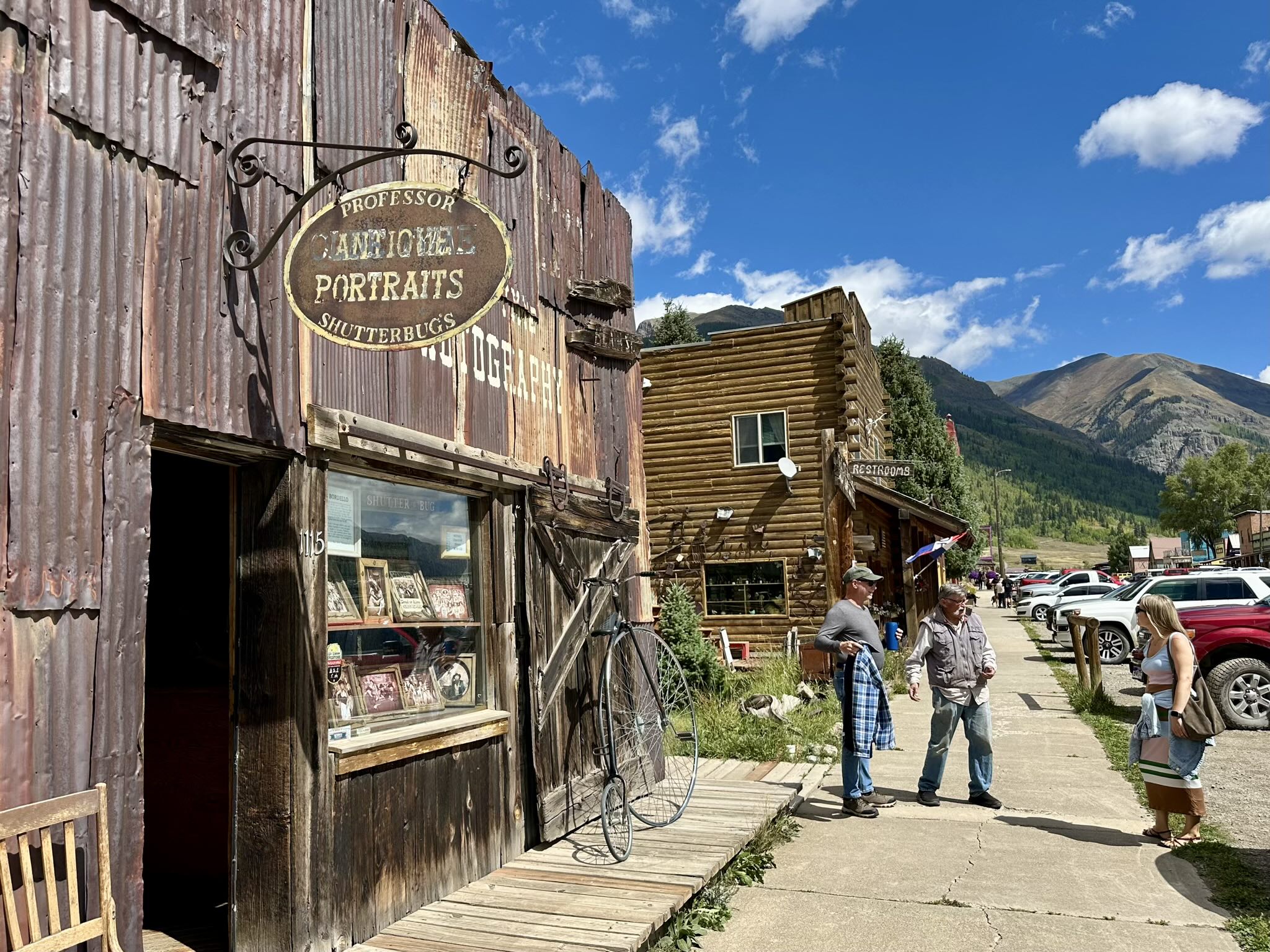
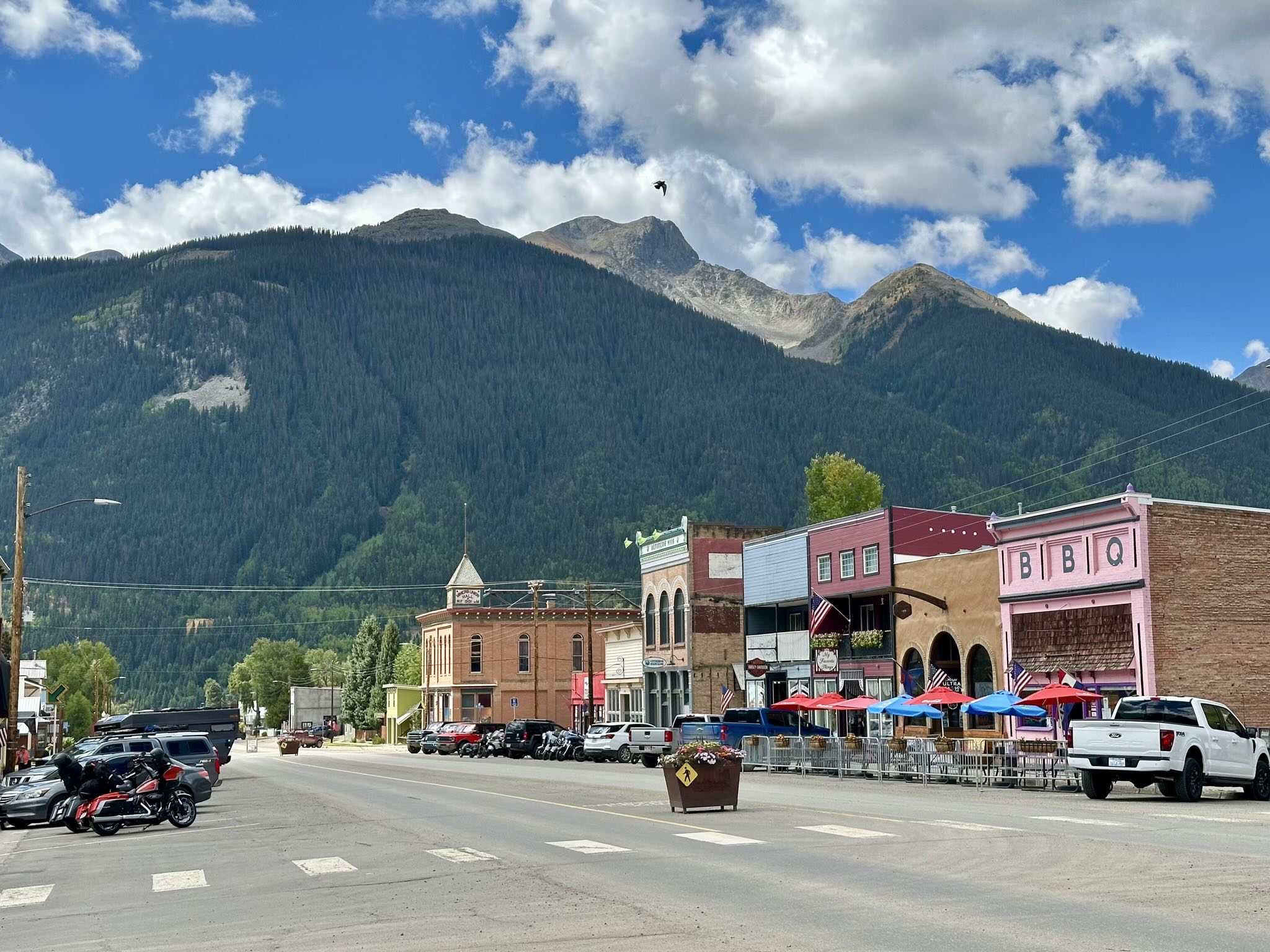
Silverton: A Slice of the Old West
From Ouray we climbed higher, stopping several times for photos—including at the Switzerland of America Lookout—before continuing toward Silverton. We passed about a dozen Porsches carving the mountain road ahead of us, probably part of a club drive, and couldn’t resist putting the top down for a stretch to feel that crisp mountain air.
When we reached Silverton, those same Porsches were parked in town. The place looked like something out of an Old West movie: false-front buildings, saloons, wooden boardwalks, and a cast of locals and bikers who could have been extras in Tombstone.
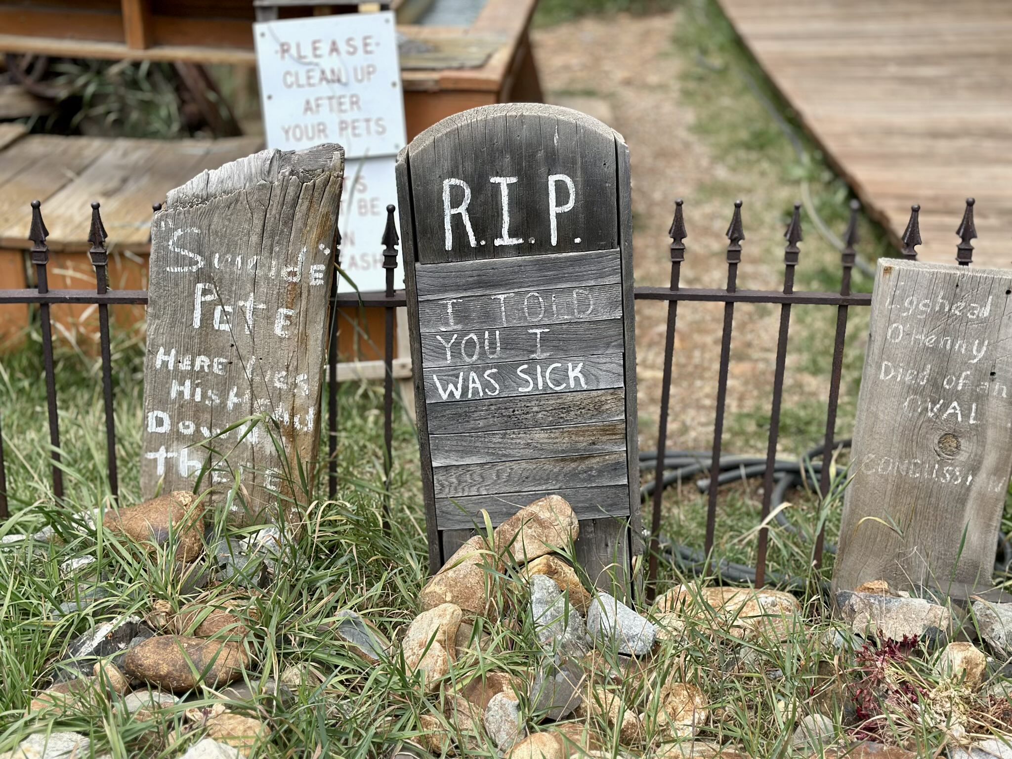
We wandered around, laughing at quirky signs—one bathroom had warnings about “explosive” use, and only 50 meters from it were gravestones that were hilarious despite their morbidity.
Silverton has a population of barely 600 residents, yet it’s rich in history. Founded in the 1870s as a mining town, it was once home to 2,000 people, dozens of saloons, and an infamous red-light district. The San Juan Mountains rise in every direction, and even though the town now survives mostly on tourism, you still feel echoes of the old frontier spirit.
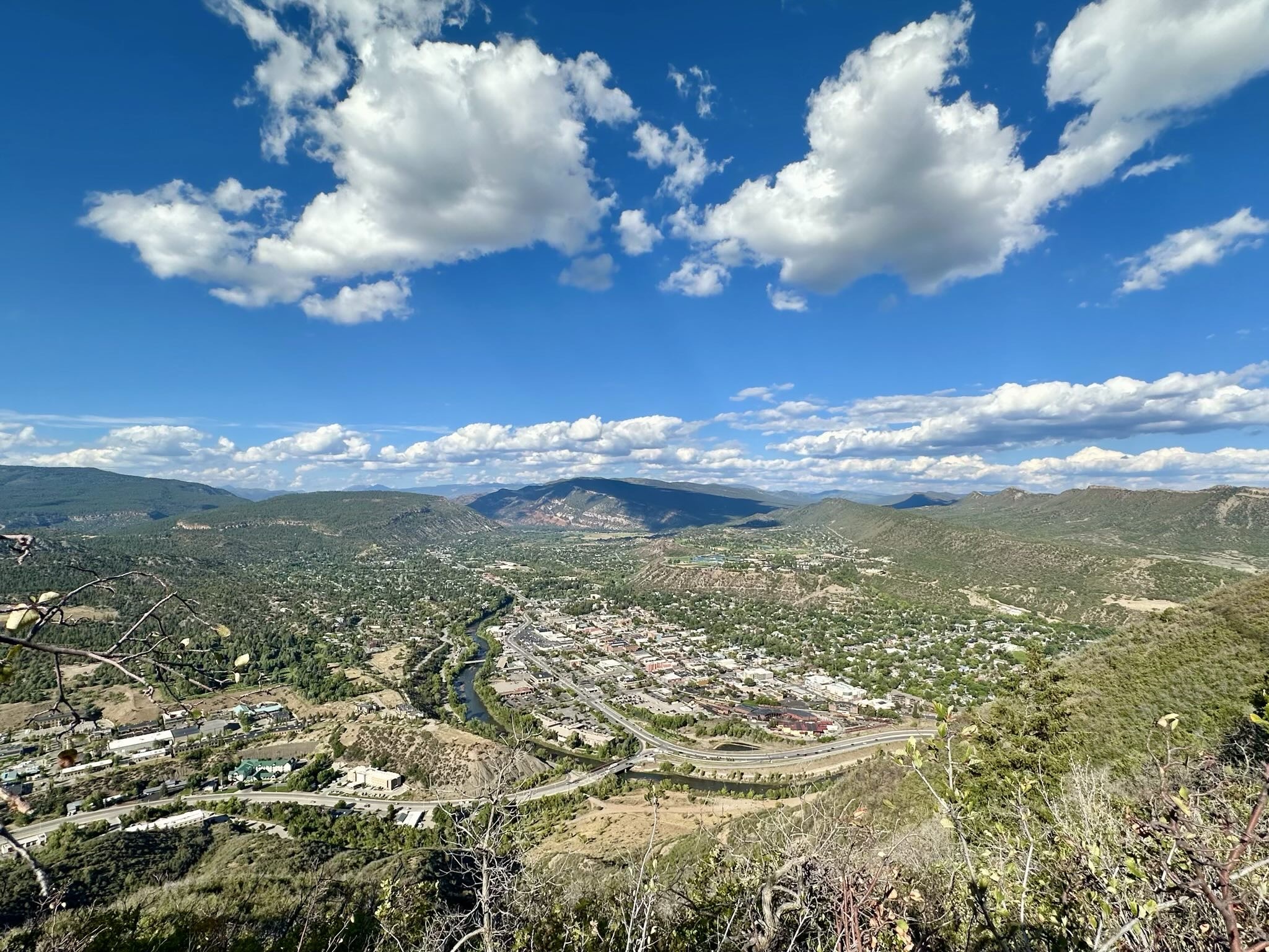
Durango
From Silverton, the road winds over Molás Pass and drops dramatically into Durango, another gem of southwestern Colorado that is home to nearly 20,000 people. We parked downtown and, to our amusement, saw the same Porsche convoy yet again—clearly we were on similar itineraries.
We grabbed lunch at 11th Street Station, a popular spot built around old service station bays that now host a half-dozen food trucks.

We enjoyed some hearty sandwiches before I noticed a flyer in the restroom promoting an upcoming documentary premiere called GC Kuss—about local hero Sepp Kuss, who had famously won the 2023 Vuelta a España. The screening was to be held later that month in Durango, with Kuss himself in attendance. We’d miss it by a couple of weeks, but it’s definitely going on my watch list.

After lunch, we explored Durango’s downtown shops and grabbed boba tea before driving up to Fort Lewis College, perched on a mesa overlooking the entire city. I have a good friend who went there for college, and I was curious as to how the campus was like. I also figured that this “college on a hill” must have great views. Well, I thought correctly—from up there, the Animas River sparkled below, framed by endless mountain ridges.
I texted that same friend, and he highly recommended hiking Smelter Mountain, claiming it would take “no more than 40 minutes.” Well… that turned into an adventure.
We initially followed a flat trail where everyone had dogs—only to realize after fifteen minutes that it wasn’t going up the mountain at all. After doubling back, we found the real trail, which turned out to be much steeper and rougher than expected. The lower section required scrambling with hands, and Andrea decided she wasn’t going to be doing that. She wisely opted to turn around, insisting that I go on ahead and that she’d wait down below.
I reluctantly continued, thinking it would be short. It wasn’t. The trail was steep, rocky, and relentless, and I would even later describe it to Andrea as “Kilian Jornet stuff.” I power-hiked up and ran much of the way down, returning to the bottom drenched in sweat. Even so, the round trip took nearly an hour. The view from the top was good, but honestly not much better than what we’d seen from Fort Lewis College.
Meanwhile, Andrea had a much more relaxing time walking by the creek below, which in hindsight sounded like the smarter choice.
Cortez
Durango is generally considered the end of the San Juan Scenic Byway, so I wasn’t expecting the drive beyond it to be all that spectacular. It turns out that was a premature assumption.
We continued west toward Cortez, a town I’d never heard of but that impressed me as we passed through. With a population of about 9,000, Cortez is one of the main gateways to Mesa Verde National Park and sits near the Grand Mesa region. It has a low cost of living, modest crime rates, and even a small general aviation airport. For travelers, it’s a convenient stop between Durango and the Four Corners Monument.

It’s a place that I’d love to come back to—along with Mesa Verde.
Four Corners (Almost)
From Cortez, it was only another hour to Four Corners Monument, the only place in the U.S. where four states—Colorado, Utah, Arizona, and New Mexico—meet at a single point. Unfortunately, I missed a turn and overshot the entrance, costing us about three minutes. Those three minutes proved vital: we arrived at 6:52 p.m., just as an employee was closing the gates.
I did not know that it was on an Indian reservation with a set closing time. But I then saw on a sign that it closed at 7:00 p.m. I called out, “But it’s not seven o’clock yet!” The employee completely ignored me. The gates clicked shut despite the protests of yet another person who just arrived (and even loudly declared that he was just going to “stay right there until they open the gate”—they didn’t), and that was that.

It was disappointing—if not for the Smelter Mountain debacle or my wrong turn, we would have made it. Later, friends consoled me by saying Four Corners was “overrated anyway,” basically just a plaque marking the state borders. One friend even claimed the marker wasn’t perfectly aligned with the actual coordinates (which, fact check, turns out to be true—it’s off by a few hundred feet). Still, it could have been fun to pretend to stand in four states at once.
Instead, we continued west toward Bluff, Utah, the sun dipping below the horizon. The sky turned gold and crimson, the mesas glowing like embers. Andrea asked me to pull over for photos, and I’m glad she did—it was one of those spontaneous moments that we’ll remember. But that’s a story for the next post.


 before joining the Uncompahgre River.")


 waiting down below as I descended Smelter Mountain.")